|

Research
As a periglacial geomorphologist, I am primarily interested
in landforms related to frozen ground and subsurface ice deposits. The
research projects on which I am currently working involve interpreting
aerial and satellite imagery to characterize the geometry of these landforms,
detecting and quantifying underlying ice content using surface-based geophysical
surveying, and relating surface morphology to ground ice volumes. Moreover,
given the demonstrated utility of geophysical instrumentation for subsurface
prospecting, I am also interested in further developing these tools for
lunar and planetary exploration. Finally, my MSc work applied computational
fluid dynamics to the design of fish habitat restoration projects. A brief
summary of each research theme is provided below.
Spatial Analysis of Polygonal Terrain on
Earth and Mars
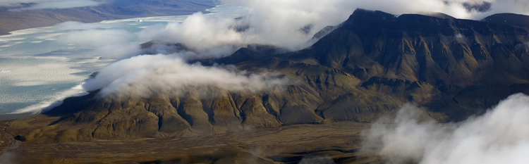
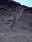
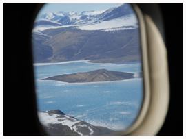
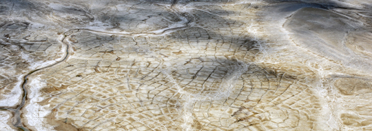
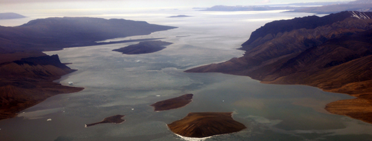
Polygonal terrain is one of the most common landscape features present
in Earth's polar regions. These networks of interconnected trough-like
features are formed through a complex interaction of climatic and ground-based
processes, and often signify the presence of ground ice deposits in the
form of ice wedges. Because landforms with similar morphologies are present
throughout Mars' polar environments, it has been suggested that ground
ice may also exist at shallow depths within the Martian regolith. While
similarities between terrestrial and Martian polygons have often been
qualitatively noted, few detailed quantitative comparisons of the two
have been performed. Moreover, although a strong theoretical framework
suggests that polygon geometry is a function of ground material properties,
this notion requires further exploration. The objectives of this work
are to:
(1) characterize polygon geometry and sediment distribution for selected
sites in the Canadian High Arctic; (2) compare the geometrical properties
statistically to sites on Mars, and: (3) use morphological variables to
develop a preliminary categorization of terrestrial and Martian polygons.
Aerial photos of each terrestrial site have been collected and georeferenced
against known ground control markers. Image analysis was then used to
quantify the parameters required to classify polygonal ground through
a statistical technique known as "Spatial Point Pattern Analysis",
which defines a given site as being random, regular, or aggregrated, and
denotes the degree to which each site is so designated.
Detection of Ground Ice using Complementary
Geophysical Tools
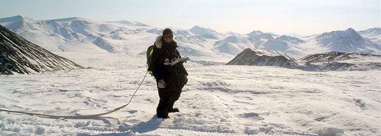
Non-invasive geophysical tools have been used extensively in previous
permafrost and ground ice investigations. Specifically, ground penetrating
radar (GPR) is effective at mapping subsurface structure, creating a stratigraphic
reconstruction based on differences in the ground materials’ response
to electromagnetic waves. Another technique – capacitive coupled
resistivity (CCR) – identifies the materials comprising the subsurface
based on the calculation of electrical resistance of the materials through
which the induced signal passes. These tools are extremely effective at
locating subsurface ice deposits, due to the drastic dielectric (GPR)
and electrical resistivity (CCR) differences between ice and the enclosing
sediments. Despite the apparent advantages of combining the data from
these two instruments, little attention to such a combination has been
reflected in the literature. Therefore, the overarching goal of this work
is to perform surveys with both instruments at known ground ice locations
to image the ice wedges and generate estimates of their volumes. At each
site, a number of parallel transects oriented perpendicular to the wedge
have been surveyed using the OhmMapper instrument (resistivity) and both
the 50MHz (deeper signal penetration, less detail) and 250MHz (shallower
signal penetration, greater detail) MALA Geoscience radar antennas. Each
transect was also surveyed with a high resolution Trimble GPS so that
the geophysical surveys can subsequently be referenced spatially. Data
has then been analyzed using Res2D and Res3D software (resistivity) and
Mala GroundVision and ReflexW (radar) software packages.
Geophysical Instrumentation for Planetary
Research
Returning to the moon to explore its shallow subsurface is extremely important
for understanding its geological history and will be a crucial precursor
for potential lunar outposts. Because no previous mission to the moon
has included widespread geophysical surveys, a detailed understanding
of the upper layers of the lunar regolith remains largely unknown. I was
recently involved in a concept study to develop a rover-based ground penetrating
radar (GPR) instrument to characterize the structure and composition of
the moon’s shallow subsurface, provide ground truth data in support
of upcoming orbital missions, and conduct initial prospecting for in-situ
resource utilization. Furthermore, it is possible that GPR may be useful
for exploring the shallow subsurface of other planetary bodies. As part
of the TandEM proposal in response to ESA's Cosmic Vision program, I am
a member of the "interiors" project team working towards developing
an air-borne GPR to explore Titan and Enceladus as a followup to the discoveries
made by the Cassini-Huygens mission.
3D Flow Dynamics around Stream Deflectors
(MSc)
The disappearance of suitable fish habitats in rivers due to land-use
changes and other factors has been extensively documented. The resulting
loss of native fish stocks is, thus, of great concern for both ecological
and economic reasons. In an effort to counter these declines, various
stream rehabilitation projects using in-stream obstructions to scour artifical
pool habitats have been widely implemented. Unfortunately, the success
of these projects has been limited due to an incomplete understanding
of the flow's response to the obstructions and how the bed, in turn, responds
to changes in flow. My MSc research used a three-dimensional computational
fluid dynamics numerical model (PHOENICS) to investigate the role of obstruction
size and angle on the flow field in a laboratory flume. Subsequent bed
topography surveys were performed to examine the role of obstruction angle
on scour hole development over time. The model was capable of predicting
laboratory velocity and turbulent kinetic energy measurements, performing
better for flow over a flat stable bed than over a deformed sand bed.
A new method of incorporating complex bed topography into a structured
Cartesian mesh was developed in the process. Flow field properties such
as dynamic pressure, velocity amplification, separation zone length and
width, and downwelling extent and magnitude were found to be strongly
dependent on deflector geometry. Equilibrium scour hole depths and geometry
are also angle-dependent. A predictive equation was produced explaining
the rate at which scour holes reach equilibrium, and compared well with
existing literature. Finally, a method was developed whereby characteristics
of the flow field over a flat, stable bed could be used to predict equilibrium
scour hole geometry.
(to top)
Short CV
(download full
CV)
EDUCATION
PhD - Periglacial Geomorphology, Geography, McGill
(expected: Dec. 2009)
MSc - Fluvial Geomorphology, Geography, McGill (2005)
BSc - Environmental Geography, Concordia (2002)
SELECTED RESEARCH GRANTS AND CONTRACTS
2008 - "Ground penetrating radar for lunar subsurface
exploration" (Canadian Space Agency; "CSA")
2007 - "Assessment of ground ice conditions in polar
desert polygonal terrain using electromagnetic geophysical methods"
(CSA)
2006 - "Comparative geomorphic analysis of High
Arctic polar desert ice wedge polygons" (CSA)
2005 - "Photogrammetric characterization of polar
desert ice wedge polygon morphology" (CSA)
SELECTED SCHOLARSHIPS / ACADEMIC AWARDS
2007 - McGill Major Fellowship in Science (2007-2009)
2005 - NSERC Postgraduate Scholarship D2 (2005-2007)
2005 - Canadian Space Agency NSERC Supplement (2005-2007)
2003 - NSERC Postgraduate Scholarship A (2003-2005)
SELECTED PUBLICATIONS
1. Pollard W, Haltigin T, Whyte L, Niederberger T, Andersen
D, Omelon C, Nadeau J, Ecclestone, M, and Lebeuf M. 2009. Overview of
analogue science activities at the McGill Arctic Research Station, Axel
Heiberg Island, Canadian High Arctic. Planetary and Space Science, 57(5-6):
646-659.
2. Dutilleul P, Haltigin TW, and Pollard WH. 2009. Analysis
of polygonal terrain landforms on Earth and Mars through spatial point
patterns. Environmetrics, 20(2): 206-220.
3. Haltigin TW, Pollard WH, Osinski GR, Dutilleul P,
and Seaquist JW. 2008. Spatial analysis of small-scale polygonal terrain
in Utopia Planitia, Mars: a comparison with terrestrial analogues. Proceedings
of the Ninth International Conference on Permafrost, Fairbanks AK: 639-644.
4. Haltigin TW, Biron PM, and Lapointe MF.
2007. Predicting equilibrium scour hole geometry near angled stream deflectors
using three dimensional numerical flow model. Journal of Hydraulic Engineering,
133(8): 983-988.
5. Haltigin TW, Biron PM, and Lapointe MF. 2007. Three
dimensional numerical simulation of flow around stream deflectors. Journal
of Hydraulic Research, 45(2): 227-238.
6. Biron PM, Haltigin TW, Hardy RJ, and Lapointe MF.
2007. Assessing different methods of generating a three dimensional numerical
model mesh for a complex stream topography. International Journal of Computational
Fluid Dynamics, 21(1): 37-47.
SELECTED CONFERENCE PRESENTATIONS
1. Williams KK, Haltigin TW, and Pollard WH. 2008. Ground
penetrating radar mapping of subsurface ice wedges in polygonal terrain
on Axel Heiberg and Devon Islands, Canada. Joint Annual Meeting GACMAC-
SEG-SGA, May 26-28, Quebec City, QC.
2. Haltigin TW, Pollard WH, Osinski GR, and
Dutilleul P. 2008. Comparative morphometric analysis of polygonal terrain
at potential Mars Phoenix landing sites. LPSC XXXIX, Mar.10-14, Houston,
TX: Abstract 2475.
3. Haltigin T, Couture N, Wainstein P, Frauenfeld O, Johansson
M, and Lantuit H. 2007. The Permafrost Young Researchers Network (PYRN):
Education and outreach for the International Polar Year (2007-2008) and
beyond. 8th International Student Conference on Northern Studies, Oct.
18-21, Saskatoon, SK.
4. Haltigin T, Pollard W, Dutilleul P, Osinski G, and
Seaquist J. 2007. Morphological comparisons of Martian and terrestrial
polygonal terrain using spatial point pattern analysis. 2nd International
Workshop – Exploring Mars and its Earth Analogues, June 18-23, Trento,
Italy.
5. Haltigin TW, Biron PM, and Lapointe MF. 2004. The
effect of structure orientation on three-dimensional flow field simulations
and bed response around paired stream deflectors. AGU-CGU Joint Assembly,
May 17-21, Montreal, QC.
6. DePascale G, Haltigin T, Lantuit H, and Turner J.
2003. RIGID – Resistivity Instrumentation for Ground Ice Detection.
European Space Agency Aurora Student Design Competition, September 8-9,
Barcelona, Spain.
(to top)
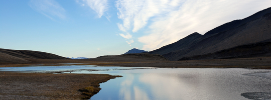
Photo Albums
Click to view galleries....
(to top)
Links
SUPERVISORS / COLLEAGUES
Wayne Pollard
- Periglacial Geomorphology, McGill (PhD Supervisor)
Pascale
Biron - Fluvial Geomorphology, Concordia (MSc Supervisor)
Michel Lapointe
- Fluvial Geomorphology, McGill (MSc Supervisor)
Gordon Osinski
- Earth Sciences / Physics and Astronomy, Western
Pierre Dutilleul
- Applied Statistics, McGill
Kevin Williams - Earth Sciences / Science Education. Buffalo State
Hugues Lantuit
- Periglacial Geomorphology, AWI Institute
Dale
Andersen - Astrobiology / Geomorphology, SETI Institute
HIGH ARCTIC FIELD RESEARCH
McGill
Arctic Research Station - Axel Heiberg Island, Canada
Haughton Mars Project - Devon
Island, Canada
SPACE AGENCIES
CSA - Canadian Space
Agency
NASA - needs no qualifier
ESA - European Space
Agency
MARS MISSIONS
Phoenix
- Scout lander exploring the northern plains (2008)
Mars Reconnaissance
Orbiter - orbital search for past/present water (2005-present)
Mars Express
- ESA orbiter (2003-present)
Mars Science Laboratory -
rover mission to search for life / characterize geology (launch: 2009)
Exo-Mars
- ESA Aurora Flagship mission; combined orbiter / rover (launch: 2013)
MARS IMAGERY
HiRISE image gallery
- HiRISE library
HiRISE
periglacial features - landforms similar to those in terrestrial polar
environments
HiRISE
landing sites - current / future Mars mission landing sites
MOC image gallery - Mars
Orbiter Camera library
LUNAR / PLANETARY EXPLORATION
TandEM
- proposed exploration of Titan and Enceladus
Cassini-Huygens
- joint NASA/ESA mission to Saturn
Lunar Reconnaissance Orbiter
- orbital preparation for future human missions
AFFILIATIONS
CLRN - Canadian Lunar Research Network
PYRN - Permafrost Young Researchers
Network
CGU - Canadian Geophysical Union
IAF - International Astronautical
Federation
MISC
Maniwaki Mauler - biting commentary
on the wide world of sports
ESPN - the worldwide leader...
Sports Guy
- best sports columnist on the internet
TSN - because ESPN's hockey coverage
is lacklustre
(to top)
|